NEFYN BEACH CORNER 1870 - 2020
(CONGOL TRAETH NEFYN 1870 - 2020)
October 2018
The town of Nefyn is located on the scenic Lleyn Peninsula in North Wales. It sits on a coastal plain one hundred feet or so above sea level and it has a beautiful sandy bay bordered by Bodeilias Point to the east and the Nefyn Point headland to the west. Tucked in the corner of the headland beneath the cliffs is the Nefyn Beach corner with four picturesque white cottages, a now concreted-over stone breakwater called Creigiau Bach and a large grassy area where fishermen can pull up their boats and at one time repair their fishing nets. Beyond Nefyn Point to the southwest is another bay, sweeping all the way to Porthdinllaen Point a long promontory extending out into the Irish Sea. Beyond Bodeilias Point to the northeast of Nefyn is a rugged coastline where the Carreg y Llam (Bird Rock) and Gorllwyn, part of the Rival Mountains, fall majestically into the sea.
The Nefyn Beach corner has an interesting history with documentation about fishing going back to the thirteenth century. The history is examined here only for a hundred and fifty year period through a series of photographs starting with the first photo taken in the 1870's. The photos, with the dates approximated, are listed sequentially in time through until 2018. They show the beach corner when the hustle and bustle of the sailing ship building industry was slowing down from its peak in the mid-nineteenth century and the quiet period that followed at the beginning of the 1900's. The photos go on to show changes to the corner from the resurrection of the old cottages, the slow demise of a wrecked fishing boat, the effect of two major cliff landslides and the changes to the Creigiau Bach breakwater.
The first photo fascinated me when I was a child growing up in Nefyn. It shows how busy the Nefyn Beach corner was when three double masted schooners were being built there in the 1870's. The three ships are supported in the upright position with wedged wooden planks along their sides and there are salvaged parts of broken ships lying everywhere around the waters edge interspersed with small fishing boats. This is the earliest and perhaps the only photograph of the corner that exists from that period. Many people, when they initially view the photograph, conclude that only one cottage named Penogfa (Herring Place) existed in the beach corner at that time. However, that is incorrect! The schooner Venus in the forefront was a large ship, large enough to nearly hide from view two other attached cottages Hen Dafarn (Old Tavern) and a blacksmiths Refail (The Forge) next door. Photo 2 shows an enlarged view from photo 1 of the back of Penogfa and the area between the two masts of the ship. Take a close look. The first chimney of Hen Dafarn is visible just to the right of the forward mast on the left side of the photo and the second chimney is in the middle between the two masts. The Refail's chimney is directly behind the second mast. There is a fourth chimney further to the right but it is from a collapsed stone building once used by fishermen to smoke herrings. So there were three cottages present in the beach corner at that time. The three cottages were built earlier in the late 1700's after the Creigiau Bach was completed in the 1740's.
Several other observations from the first photo are worth making. Note the depth of the stone foundation exposed at the rear wall of Penogfa. The cottage appears to have been built on a sound foundation. The ground behind Penogfa was dug out to accommodate a long saw pit for the ship builders. The pit was where tree trunks were trimmed and sawed to the required dimensions for different parts of the ships. The sawyers used two-man saws with one person in the pit below pulling on the saw and another on the top pushing and guiding the cut. Sawed planks can be seen on the right side of the pit in photo 1.
Another observation is that the Venus bowsprit is positioned well into the side of the cliff. From the placement of the ship's masts and knowledge of the contour of the land beyond the gable end of Penogfa (where the old well is located), the center of gravity of the Venus is positioned sufficiently forward for the keel at the stern to be elevated and sticking out over the beach. The keel may have been supported at the stern although that is not clear from the photo. If so, that made for good planning by the builders since it allowed for an easy launch when the ship was completed. The launch was probably on rolling logs with support provided on both sides as the ship was pulled slowly stern-first into the sea at high tide.
The last observation is that the Creigiau Bach breakwater was a key enabler for building the cottages and for the ship building and fishing activities. Before the 1740's the corner had just been partially protected by Creigiau Mawr, the natural rocks running along the headland, but the protection was significantly improved after Creigiau Bach was completed. First the breakwater provided calmer waters in the corner. Secondly it allowed soil, mostly from cliff landslides, to build up along the cliff edge within the corner and to prevent the soil from being washed away by the sea at high tide. The land area expanded sufficiently to allow the building of the three cottages, the fishermen sheds and the elevated area where the two smaller schooners are shown on the right side of photo 1. A retaining wall to contain the area is shown below the ships and just above the wreck sitting in the water. The retaining wall provided further protection on the inside of the breakwater and it made the area, with a slipway at both ends, a convenient place for ships to be built and launched. The area later became grass covered and became a convenient place for fishermen to park their boats and nets.
The large boulders at the tip of Creigiau Bach was also a place where iron rings were embedded to assist in ship launching. It was probably the case when the Venus was launched in 1880. The ship's keel was coupled with rope to a winch at the base of the cliff via a pulley attached to those iron rings. The winch then provided the slow seaward pull on the ship required during the launch.
One puzzle worth mentioning is that the last three sailing ships built at Nefyn, listed on www.rhiw.com, were the Walter Urich (1875 - 2 masted schooner); the Ebenezer Parry (1877 - 3 masted schooner); and Venus (1880 - 2 masted schooner). None of the schooners shown in the photo have three masts! I have not pursued this puzzle any further.
There were no people living in the cottages during the 1870's according to census information. But based on their names, the cottages did have occupants in earlier years. The Refail was a small blacksmith workshop for making anchors and other iron items for the sailing ships. The Penogfa and Hen Dafarn cottages were simply sheltered places for planning, coordinating and supervising the ship building. There were times when two owners were building ships at the same time, using separate or the same work force, so good coordination was essential. The industry employed people with a variety of skills including shipwrights, carpenters, sawyers, painters, blacksmiths, turners, block makers etc … as well as a large number of unskilled laborers. Many were employed in small workshops in Nefyn making nails, ropes and sails for use on the ships but the majority worked in the beach corner. They came from small villages all over Lleyn. They walked from Ceidio, Dinas, Tudweiliog, Edeyrn, Morfa Nefyn, Pistyll, Llithfaen, Llannor etc. in all kinds of weather and, as they approached the beach from the south or west along Tyn Pwll Lane, they turned towards the headland, exited through a kissing gate at the top of the cliffs and down a path behind Penogfa on to the beach by Hen Dafarn.
This was the time when Nefyn was at its entrepreneurial best and the town will probably never be as innovative again. The industry was home grown and stemmed from the expertise local fishermen acquired building their own boats and single masted sloops. The local talent not only designed and built the ships but also financed their construction, sold shares in their businesses, captained, crewed and sailed the ships all over the world. They even initiated an insurance business underwriting the ships and their cargoes which was as lucrative a business as the ship building itself. Nefyn was viewed as an important center for shipping commerce and the companies in town insured other ships from various ports around Great Britain. In 1878 the combined valuation of vessels insured by the Nefyn companies was in excess of two million pounds.
The prominent people in town in those days were the ship owners, ship builders and ship captains, true leaders with occupations contributing directly to the wealth and well-being of the community. They were the successful individuals who started building the large homes in the west end of town. The period stands in sharp contrast to the downturn that followed at the beginning of the twentieth century when solicitors and bankers became the most affluent people in town. They took over those west end houses but, because of the nature of their jobs, contributed little to the wealth and growth of the general population within the area.
Given its historical significance, the Nefyn Beach corner should be hallowed ground for local people, but it was not so. It amazed me when I was young how the descendants of many older local families treated the corner with such indifference. They were not interested in the beach and some children I knew at school never set foot in the corner even though their forefathers toiled there throughout their working lives. The community did in later years convert the old St Mary's Church into a museum highlighting with artifacts and photographs the importance of the sea and the beach corner to the history of the town. The museum is now a well established and an unique visitor center in the area.
Photos 3 and 4 were both taken thirty years later around the turn of the century after the shipbuilding industry had collapsed. The sailing ships and their piece-parts were gone and very little traces of the industry remained, just one large winch and a few iron rings embedded in the rocks of Creigiau Mawr. Also a large anchor or two, one of which is shown in the photo, embedded in the sand by the slipway at the stern of the boat in the background. The entrepreneurial spirit had subsided and the beach corner was back to its prior status with just local fishermen plying their trade.
There were forty small fishing boats operating out of Nefyn in 1910, some powered by rowers and some by sails. The rowing boats were double ended, manned by three or four net owners with three men rowing and one handling the tiller. The person on the tiller was usually the boat owner. The sailboats operated with just two men. They fished in the greater Nefyn Bay area and reluctantly traveled west beyond Porthdinllaen Point towards Bardsey or east beyond Gorllwyn towards Caernarfon only when the herrings were scarce. Rarely did they stay at sea overnight and if they did, it was for one night at the most. The herring season ran from October through February, the coldest and shortest days of the year and when storms were frequent and bitter. The Irish Sea was not a place to be caught in a storm during those months. The nets had to be fished early morning and every few hours during the day. They had to be moved regularly otherwise they were cleaned out by seals who patrolled the nets once they were found. One grey seal could devour a hundred herrings in no time and could ruin a net if it accidentally got caught in it. There was no room in those small boats to store fish and herrings spoil easily if they were kept for too long. They had to be brought ashore promptly after they were caught to be smoked or salted in barrels.
The herrings caught on the north side of the Lleyn Peninsula had a reputation of being the highest quality. They were bigger, tastier and much preferred over those caught on the southern side of Lleyn in Cardigan Bay or indeed from anywhere else in Wales. Since Nefyn was the only large town on the north coast, their herrings (Penwaig Nefyn) became famous thorough the land. The town became known as the herring capital of Wales. Nefyn to this day proudly displays three herrings on its coat of arms and a sailing ship on the tower of the old St. Mary's Church on Stryd y Llan.
In 1900 a prominent property owner on Nefyn Beach was William Thomas. He was Nefyn born and was the manager of the Metropolitan Bank in Bangor. Records indicate he was the owner of the two cottages Hen Dafarn and Refail and also the small parcel of land between Hen Dafarn and Penogfa where the schooner Venus was built. The cottages had been unoccupied for years and they were in a decrepit state, just stone walls with a roof on top and in urgent need of repair and renovation. Nefyn was rapidly becoming a holiday destination for English visitors and, with the advent of a railway terminal in Pwllheli seven miles away, the number of visitors to the area was increasing rapidly. Properties in close proximity to the sea were growing in value. Thomas was eager to upgrade his cottages and to ensure an easy and permanent access to them via the path from the cliff top.
Well established footpaths existed from the front of the cottages in both directions, through to Creigiau Mawr on one side and to the sandy beach leading to Screw Road (Lon Gam) on the other side. The footpaths were used by working men moving back and forth and carrying parts to the ships being built in different areas. When the tide was out, they could walk on the sand but with the tide in they used the footpaths. The footpaths were located on the strip of land between the front wall of the cottages and the high water mark where the fishermen parked their boats as shown in photos 3 and 4. In photo 3 a group of five fishermen pose in their boat on the strip in the middle of other boats. The poor state of the cottages can be seen on the left side of the photo with Hen Dafarn on the extreme left and Refail directly behind the first fisherman. The footpath is visible to the right of the second fisherman and just above the third. Photo 4 shows a boat pulled right over the strip in front of Hen Dafarn. The cottages look a bit more respectable after being whitewashed. Both photos were taken around the same time since the large anchor in the sand by the slipway is visible in the two views.
On the 19th of March 1903, William Thomas signed an agreement between the Fishermen of Nevin, himself and representatives of the Nevin Parish Council. The agreement stated as follows :-
“I William Thomas, Manager Metrropolitan Bank, Bangor willingly agree to the resolution passed at a meeting of the representatives of the Nevin Parish Council and the fishermen of Nevin at the Madryn Hall on the 10th day of March 1903 to the effect that I give to the Fishermen of Nevin for all time an absolute right to the usage for laying their Boats and Nets and for other Fishing purposes, of a plot of ground belonging to me (the same area as that which I enclose) and situated at the bottom of the Cliff or Glanymor Nevin and contiguous to the plot of ground to which they already have a right of utilising for fishing purposes, in exchange for their rights on a portion of the said land in front of and at the gable end of the two houses belonging to me in Glanymor and which portion of land measuring (net) three yards in front of the said Houses, and four feet at the gable end I intend enclosing. Signed W Thomas, Bangor 19th March 1903”.
I do not have a copy of the map showing the “plot of ground belonging to me” area he was referring to in the agreement. I was led to believe it was the parcel of land between Penogfa and Hen Dafarn where the Venus was built. It was the only piece of land that was contiguous with the land on the gable end of Penogfa already being used by the fishermen as mentioned by Thomas. The reason why he was seeking the agreement becomes clearer in photo 5 taken nearly twelve years later at the beginning of WW1. The front wall of Refail had structural problems and supports were needed to prevent the wall from collapsing. The stone supports had to extend from the front wall across the footpath and into the strip to be effective. Hence the request from Thomas for an easement of “(net) three yards in front of the said Houses” from the fishermen in exchange for the Venus site. The footpath was moved further out and two triangular stone buttresses were built against the front wall of Refail after the agreement was reached.
By the time photo 5 was taken, the buttress walls were also whitewashed and the cottages looked much better. They were also connected to fresh running water since this was a necessary requirement for the cottages to be occupied. The Parish Council built a reservoir on Mynydd Nefyn in 1906 and running water was available throughout the town and in the large houses on the top of the cliffs soon afterwards. It was a simple task to run a buried pipe down the cliff and into the cottages. Water pressure in taps at beach level was not a problem. Prior to that time, fresh water was carried in buckets from the old well by Penogfa or from springs on the side of the cliff. With an abundance of running fresh water, someone had washed a lot of clothes in photo 5 and the items were proudly displayed drying on a long line along the gable end of Hen Dafarn.
By 1915 other changes had been made in the corner as shown in the same photo. A retaining wall had been built by the Council on land used by the fishermen extending from Penogfa all the way along the front of the two cottages except for a sloped concreted-over gap near the old well. The wall was approved by the fishermen and the sloped gap acted as a short slipway allowing easy access to both their boat areas on the gable end of Penogfa and the Venus site in the Thomas agreement. The retaining wall nearly occupied the whole width of the fishermen strip along the front of the cottages and it provided protection for the footpath. The wall had a flat top approximately a yard wide and was often used as a convenient alternate to the footpath. In photo 5, an identical retaining wall was built to protect the grassy area on the far right where the footpath entered Creigiau Mawr. Clearly the intent by all involved was to protect the properties, the footpaths, the areas used by the fishermen and to ensure everyone had continued access to all parts of the beach corner.
A drain was installed beneath the retaining wall during its construction. Its function was to upgrade drainage from all three cottages. The land behind the cottages had to be drained of run-off water from the cliffs and water from the newly installed back roof gutters. The drains came around the sides of Hen Dafarn and Refail to merge with drains from the front roof gutters and from wastewater pipes inside the cottages. The merged drain ran under the retaining wall at the gable end of Refail and was buried deep in the sand below the high water mark. The water percolated into the sand and was dispersed at every cycle of the tide. The drain was covered with rounded concrete and was visible when the sand level was low in front of the retaining wall. The drain requirements around Penogfa were different since its gable ends faced the cliff and the sea, but they accomplished the same objective. Our parents warned us children to stay away from playing in those areas at low tide in case the sand was contaminated.
The saw pit behind Penogfa was filled in and a row of sheds were built over the site as shown on the left side of photo 5. The first shed directly behind Penogfa was large and was owned by the Parry family of the Nanhoron Arms Hotel in Nefyn. Then there was a row of several small corrugated sheds for fishermen before there was another large shed belonging to the Bryn Beuno house on Tyn Pwll Lane. Bryn Beuno was built for a Captain Evan Jones of Nefyn who sadly never saw the house completed since his ship was sunk by the Germans with all lives lost on May 23, 1917. The house was sold afterwards to a Mr Cowburn a retired town clerk from Leigh in Lancashire. The two large sheds were called the Parry and Cowburn sheds in my days. Both had slipways built in front extending into the sea at high tide. The fishermen and part time fishermen who later occupied the small corrugated sheds were Dic Jones (Dicw), Gwilym Shop Newydd, Wil Evans Jones and John Robert Hughes. Two more sheds were added in front of that row with the footpath accommodated between them. Those two sheds were occupied by Huw Bryn Beuno, the son of Captain Evan Jones, and Richard Hughes and his sons Meirion and Trefor from the Fron in Nefyn.
Photo 6 is dated 1920 and is titled on the front “A Quiet Spot Nevin Bay 20”. In the forefront is the wreck of a fishing boat that belonged to Robert Humphries and John M Jones (Jac Main) both of Nefyn. The masted fishing boat slipped its mooring in a northwesterly gale in the early summer of 1920 and was driven over the boulders on the tip of Creigiau Bach sustaining serious damage. The wreck settled in the sand in front of the two beach cottages and left there. It became a favorite spot for children to play. The photo captures the old path used by the workers coming down the cliff during the ship building era behind Penogfa and entering the corner by the side of Hen Dafarn. That path was being used less and less since two other paths had been established. One is shown zigg-zagging down the cliff behind the two cottages in photo 5 and the other is shown behind the fishing boat's mast in photo 6. The latter is part of the current path into the beach corner but at the time, due to a spring in the middle of the cliff, the path took a sharp turn to the right and emerged on the sand by the bathing huts on the left side of the photo.
The Fishermen of Nevin during those days were a well organized group with a large membership and supported by the likes of William Thomas. They were very successful in ensuring the rights of their members in the beach corner. However, during WWI, the membership dropped off dramatically. Fishing was an occupation for young men and most of the young men in Nefyn had been enlisted in the War effort. Also at that time, there was a severe decline in the herring population in the Irish Sea. The herrings had always cycled from periods of glut to periods of shortages when they never showed up in coastal waters. There was a major shortage during WWI and, since it was a staple diet for local people, it caused additional hardships within the community. The influence of the fishermen declined during the War and never fully recovered.
By the mid 1920's, another person of prominence appeared on the scene who played an important role in the beach corner. His name was John Turner and he lived next to the Methodist Chapel on Well Street in Nefyn. His grandfather Thomas Turner had extensive dealings with leased lands for Spencer Buckeley Wynn, Lord Newborough of Glynllifon Park. The Glynllifon Park estate owned all the land around the beach as well as parts of Nefyn town and the names 'Glynllifon' and 'Newborough' are still in use in the area. Thomas was the estate representative in Nefyn and in the 1870's, he was also the owner of the Sportsman Inn in town. The term 'owner' is used here without differentiating between a leased property or a freehold property. John Turner took over the estate responsibilities from his grandfather after WWI and along with William Thomas, was a member of the Parish Council. Turner was involved in most property/land transactions in the beach corner and was also the owner of the cafe he built at the bottom of Screw Road (Lon Gam) then called Cafe Turner. He collected the annual rent for Glynllifon on all the leased beach properties, as was the case for the fishermen sheds. He also collected local taxes on private properties for the Parish Council. He rented bathing huts to visitors from the cafe, locating those huts on the cliff edge as shown on the left side of photo 6.
Around this time, John Wales who lived in Plas Tirion on Lon Uchaf in Morfa Nefyn negotiated with Turner to purchase the Penogfa cottage. He was an engineer who came to the area around 1888 to take charge of the telegraph relay station at Cable Bay in Abergeirch connecting Great Britain to Howth in Ireland. A new cable had been installed which carried both telephone and telegraph signals and Abergeirch was a key terminal in the communication link between London and Dublin. John Wales was a prime mover in establishing the Golf Course and the Golf Clubhouse on Porthdinllaen Point in 1909. His eldest daughter Vivienne later ran the Ashdene Hotel across the road from Plas Tirion. John had an office in Ashdene and Prime Minister Lloyd George was a frequent visitor when he was home in Llanystumdwy from London. He wanted to receive updates from London and directly from Dublin during those turbulent years in Ireland. The Ashdene in the 1930's became the well known Cecil Hotel. I was told the change in name occurred after the owners bought a large amount of china from an identically named hotel that went out of business in London. The china was decorated with the Cecil name, a great marketing tool for enhancing the prestige of the hotel in the Lleyn area. The purchase of Penogfa was the first step for the Wales family in Nefyn and more steps were to follow later.
Like William Thomas, John Wales was supportive of the fishermen and cognizant of their rights. His eldest son, also named John, loved the sea, was an avid fisherman and became a ship's captain on trans Atlantic convoys during WWI after learning his naval skills on the bay in Nefyn. Like many other local sea captains, he lost his life near the end of WWII when his ship was torpedoed by the Germans off Madagascar in the Indian Ocean.
Photo 7 was taken around the same time as Photo 6 with the photographer standing on the wreck of the sailing boat. It is a close-up showing the retaining wall in front of the cottages together with the gap by the old well. There are boats everywhere around Penogfa, on its gable end facing the sea and on the Venus site in front of the cottage. The photo also shows the high tide reaching close to the edge of the retaining wall.
Photo 8 dates approximately from around 1930. As indicated earlier, there were only three cottages on the beach at the time, the fourth cottage Hafod y Mor had not yet been built. Its eventual site on the right of the photo was occupied by a hut used to smoke herrings. The hut replaced the stone building that collapsed earlier. Both photos 7 and 8 show the retaining wall had been extended further towards the slipway. The hull of the wrecked fishing boat was now reduced to a bare keel and a few remnant ribs.
Photos 9 and 10 were again taken in the early 1930's and they highlight the first large landslide that occurred at the beach corner during the period. The landslide did not damage any buildings and occurred just beyond the Cowburn shed where the LaCasina cafe was later located. It was caused by the previously mentioned spring on the cliff and by an excessive amount of rain. The landslide scarred the cliff and rubble from the slippage extended way out on to the beach. Both photos show water flowing from the spring over the muddy slippage area. Horse and carts were used in those days to help disperse the rubble along the beach. The smoke hut by this time had been replaced with a modern beach shed shown just above the fishing net.
By 1933 a person named Wilfred Spencer purchased the two cottages and proceeded to build a third cottage Hafod y Mor next to Refail. Hafod y Mor was a large house and it was set further back than the other two cottages. Its ground floor was also elevated making it less likely to flood and making the drainage easier. The house was completed in 1935. That same year Wilfred Spencer passed away leaving the cottages to his three children as holiday homes. Dorothy Spencer owned Hen Dafarn, Harold Spencer owned Refail and Geoff Spencer owned Hafod y Mor. They visited the cottages for a holiday every year and rented them out to visitors for the rest of the summer. Some visitors enjoyed coming to Nefyn and became regulars renting a cottage year after year. Photo 11 shows occupants with cars parked on the beach in front by the retaining wall. Notice that new vegetation had grown over the landslide area and the keel and ribs of the old fishing boat were still visible on the beach.
Around this time, the Wales family made further purchases in the beach corner. Two daughters Miriam and Evelyn purchased land on the site of the landslide beyond the Cowburn shed and built the famous LaCasina cafe on that site. A long retaining wall with adequate drainage was built on the beach below the cafe and large boulders were placed out on the beach to provide a buffer for the retaining wall. The water from the spring on the cliff was diverted into a small stream on the left of the retaining wall and a bridge was built over the stream to allow the path to pass in front of the cafe and emerging by the Cowburn shed. The LaCasina cafe was built in 1936 and was a landmark on the beach for twenty five years. In 1937, the two Wales sisters also built a cottage named LaCasina on the site of the old Bol Llaeth tavern on Tyn Pwll Lane and during WWII a brother Eric Wales moved to live in Penogfa with his family. His son Patrick was my age and attended Nefyn School and now lives in Melbourne, Australia. Photo 12 shows the beach corner in 1950 with the cliff path and the retaining wall in front of the LaCasina Cafe. I have fond memories of purchasing lunch trays from the cafe when I was working as a teenager in the beach corner from 1954 until 1959. By 1950 as well, John Turner had retired and had sold his cafe at the bottom of Screw Road to Huw Bryn Beuno, so Huw then owned properties at both ends of the beach. Cafe Turner then became known as Cafe Huw Bryn Beuno. By 1950 also, the keel of the old fishing boat had finally disappeared under the sand in front of the cottages.
Photos 13 and 14 show the Nefyn Bay corner from the cliff top and with a northwesterly perspective. Photo 13 is also dated around 1950 and shows two rows of attached sheds Turner built on the grassy area beyond the cottages. They were located between the footpath and the cliff and were rented to local fishermen and English visitors. The occupants of the three, black roofed sheds from the left were Mr Hughes, London House, my father Lawrence Owen and a Mr Wilcox respectively. The Wilcox family also used to rent both the Hafod y Mor and Refail cottages from the Spencer's. Mr Hughes lost his son Hefin Hughes in 1950 when Hefin and another young Nefyn man Humphrey Davies drowned at sea after they attempted to sail to Angelsey on a cold January morning. After that tragic loss, Mr Hughes sold the shed to the Buckley and Murray families who later moved to a house on the beach at the bottom of Lon Bwlch in Morfa Nefyn.
I only remember one fisherman in the row of five attached sheds with grey roofs on the right near Creigiau Mawr. He was Wil Jones who lived first in Stryd y Llan and later in Tai'r Lon. His eldest son Gwilym Owen Jones was in my class at Nefyn School. The other sheds, together with the separated sheds at the end, were rented or owned by visitors. One of the occupants in the row were the Partingtons who had a large summer home called Gwenolfa (Swallow Place) on Nefyn Point. The younger son William Partington later owned the Partington Marine Company in Pwllheli. I also remember a religious, elderly English lady living in one shed during the autumn months. She was originally living in a house in the Fron but could not pay the rent. She had to leave the house and decided to rent the shed on the beach. It was a dire situation with winter coming, and she was given financial assistance by the parish and moved elsewhere.
The occupant of the small shed nearest to Creigiau Mawr was a Dr. Walsh who had bought the shed from Wil Evans Jones. My father used to take care of the Walsh's boat and they owned a summer home behind the Cliff Castle at the top of Lon Gam. Their son Robin Walsh was the young man who was accused in July 1983 of misappropriating funds from a defence contract while working for the UK Ministry of Defence in Oman in the Middle East. Before there was even a trial, the British general in charge decided to make an example and Robin was turned over to the local authorities. He was left in an Omani jail over the Ramadhan weekend with no water or air conditioning. He sadly died there from heat exhaustion. I remember going mackerel fishing with my father and Robin when he was on holidays in Nefyn. He was five years older than I was and I remember him as a quiet, respectful, bespectacled and smart young kid who couldn't hurt a fly. It was a tragic loss of a bright young man who was only forty seven years old when he died. Details from the case are still shrouded in mystery and will probably be never fully explained.
Six other individual sheds, shown above the sailboat in photo 13, were built in the area between the two rows of sheds and in close proximity to the old ship winch. They were occupied by locals Hughes Bach Town Hall, Dick Pant, Maurice Jones, Captain Baum and Robin Roberts Stryd y Llan and two other visitors. The photo also shows the cliff path that zigg-zagged down from the headland behind the Hafod y Mor cottage. I used that path often when I was a child since it exited close to our shed. The LaCasina cafe and the retaining wall below are shown clearly, together with the footpath extending around the whole corner. Two small buildings, seen in the photo above Penogfa, were erected on the cliff side behind Hen Dafarn. The one on the left was quite large and the one on the right was small and appeared to be an outhouse. Dorothy Spencer the owner of Hen Dafarn was a teacher from Blackburn and was resident in Nefyn throughout the school holidays. She lived in the large building in the back while renting the cottage to visitors.
Around 1954, a second major landslide occurred next to the Hafod y Mor cottage as shown by the scarred cliff side in photo 14. It took out completely the footpath that zigg-zagged off the headland. The slippage destroyed three small sheds but did no damage to the one owned by the Barraclough family right next to the row of sheds. This is another family that also experienced a tragedy at Nefyn. The parents were separated, with the father staying at the Caeau Capel Hotel and the mother living in the Conway Valley. He was a very pleasant English gentleman, a 'Sais clen' as was often said in Welsh. He owned a cabin motorboat named the Carolyn Mary and he enjoyed the boat with his children when they were visiting in Nefyn. The family lost their youngest son Nicholas in a gun accident in the Conway Valley in 1957 when he was only ten years old. My brother Terry who was ten in 1958 used to play with Nicholas on the beach. Mr Barraclough suffered from bad bombing experiences during the War, a condition now referred to as PTSD. He committed suicide in the shed on Nefyn beach in 1958, a year from when he lost his son. A very sad occurrence. My father found him in that shed one early morning when he was going mackerel fishing.
Immediately after WWII, there was a great deal of co-operation between everyone in the beach corner. People were exhausted from the War effort, the country was drained financially and rationing was still in effect. Money was scarce, everyone felt poor and they respected and trusted one another. The fishermen regarded the grassy areas as common land and allowed anyone to park their boats there, irrespective of whether they were used for fishing or pleasure. They helped each other drag their boats to safety off the beach during stormy weather. There were strict rules and penalties for catching salmon at sea with nets, since they affected the salmon population in local rivers fished by estate landowners. But otherwise there were no other fishing restrictions. Likewise, the local Parish Council had not yet realized the beach as a source of revenue and everyone was allowed to do their own thing.
Several fishermen made a living hiring rowing boats to visitors, organizing early morning mackerel fishing trips and taking visitors on twice-daily sight-seeing excursions to Bird Rock. That was the environment I was brought up in and it was tough to make a living. But things were changing and improving when we entered the 1950's. In addition to Lloyd George starting social security pensions for the elderly earlier in the century, Aneurin Bevan started the National Health Service in 1948 and free college education was available to children who qualified and whose parents could not afford it. I was helped immensely by that program in the 1960's. The local economy was expanding and the number of visitors to the area in the summer were increasing rapidly year over year. Local hotels were full and house owners were living in their garden sheds while renting out their homes one room at a time to people from Manchester and Birmingham. Everyone was benefiting from the growth and house prices in the area were rising rapidly. On the positive side for the fishermen, new markets were opening in Europe and their catches of lobsters and whelk were picked up weekly by tanker lorries and delivered across the Channel. On the negative side, the heavy, clinker-built rowing boats rented to visitors were being phased out by molded fiberglass boats which could be easily towed to their holiday destinations. The visitors did not have to rent a boat anymore, they could bring their own.
The fishermen were still not strongly represented on the Parish Council and that was okay since they regarded the council members as a bunch of farmers with no interest in the seashore. But it was not okay if the fishermen sensed there were violations or encroachments occurring on their beach domains. John Turner was not regarded as a friend and his motivations were always viewed with suspicion. The fishermen formed a small committee of around ten members to oversee their interests. They included Dick Jones, Meirion, Gwilym Shop Newydd, Osborne, Captain Baum, Wil Evans Jones, Captain Dick Lloyd, John Robert Hughes, Huw Bryn Beuno and Lawrence. Among other things, they shared copies of the Thomas 1903 document so each member knew the areas that needed scrutiny. They were a small but formidable group determined to keep the footpaths open especially at that crimp point in front of the three cottages. I remember being told to use the footpath whenever the sea was up to the edge of the retaining wall and to always be courteous when using it. I also remember feeling awkward walking past the front of Refail through a group of strangers sitting on the retaining wall or on deckchairs, unaware they were blocking the footpath. It was not a problem when the elder Spencer's were present but it was difficult with unfamiliar renters. I was always glad when summer was over and the cottages were empty so we could walk wherever we pleased on the beach.
I remember the mid 1950's when photo 15 was taken. Eric Wales had built a new house on Tyn Pwll lane and the Seth family owned Penogfa. Dick Jones (Dicw) used to repair his herring nets draped over his boat on the Venus site right in front of Mr Seth's cottage. Dicw enjoyed working in that area since it was close to his shed and he and Mr Seth conversed there often over a cup of coffee. The photo shows Mr Parry, Michael Parry's uncle and part owner of the Red Garage, departing after a chat with Dicw. The footpath is shown on the right of Dicw and is narrowest, as explained earlier, just where Mr Parry is walking in front of Refail. It is about a yard in width as measured between the ground edge of the support wall and the inside edge of the retaining wall. Mr Parry is not walking on the footpath but on top of the retaining wall towards the grassy area in the upper right corner.
I left Nefyn for college in September 1959 and subsequently only returned for two weeks or so in the summer. I lost touch with the changes that occurred in the beach corner and perhaps for the better since like many others, I was not happy with what happened there. The LaCasina Cafe apparently was closed in 1961 due to the poor health of one of the Wales sisters. The property was sold and replaced by the house on stilts more suitable for Key West, Florida than the beach corner in Nefyn. How the plans for that house was approved by the Parish Council was beyond me. They also permitted the building to have its own slipway located within a few feet of the Cowburn slipway. Then to cap it all in the mid 1980's, the Creigiau Bach breakwater was cemented over without any measured thought as to the consequences. Instead of looking like a natural corner, it looked like any other ugly harbour at low tide. The huge concrete barrier blocked the sea view from shore and it forever changed the seascape in its vicinity. Sand could no longer filter through the breakwater and the sand built up to such a depth, it had to be removed almost every year. I was told the patch outside the breakwater where fishermen dug up lug worms in the sand as bait for cod and whiting had disappeared, together with the small sea grass area on the inside of the motorboat moorings. The remnants of Jack Main's fishing boat was buried forever in front of the cottages.
Throughout the years, my parents continued to enjoy going down to the beach corner and sitting on deck chairs in the front of the shed in the sun every summer. Terry and I purchased the shed for them when it became available so they could continue to do so for the rest of their days. Photo 16 shows them with Terry in front of the shed in the mid-1960's. I last visited Nefyn in 2018 and made a point of standing close to where Dicw stood repairing his nets over sixty years earlier. The view along the front of the cottages, as shown in photo 17, towards the grassy area where my parents used to sit was still impressive, but a section of the old footpath nearby had disappeared. That section is behind my father's elbow in photo 16. Conflicts between the cottage owners and the fishermen obviously continue to exist and will in the foreseeable future. It is up to the young Nefyn fishermen to stand together, garner support from the Parish Council and defend their rights in the beach corner just as their grandparents and their great grandparents did in the past. I hope my memories of the place, summarised in this article, can contribute somehow towards that cause.
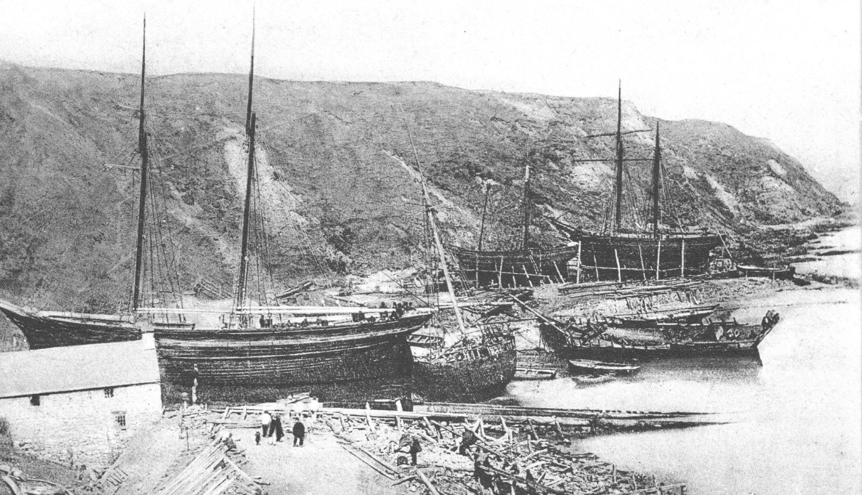
Illustration 1 Nefyn Beach Corner 1875
(Click photo to enlarge)
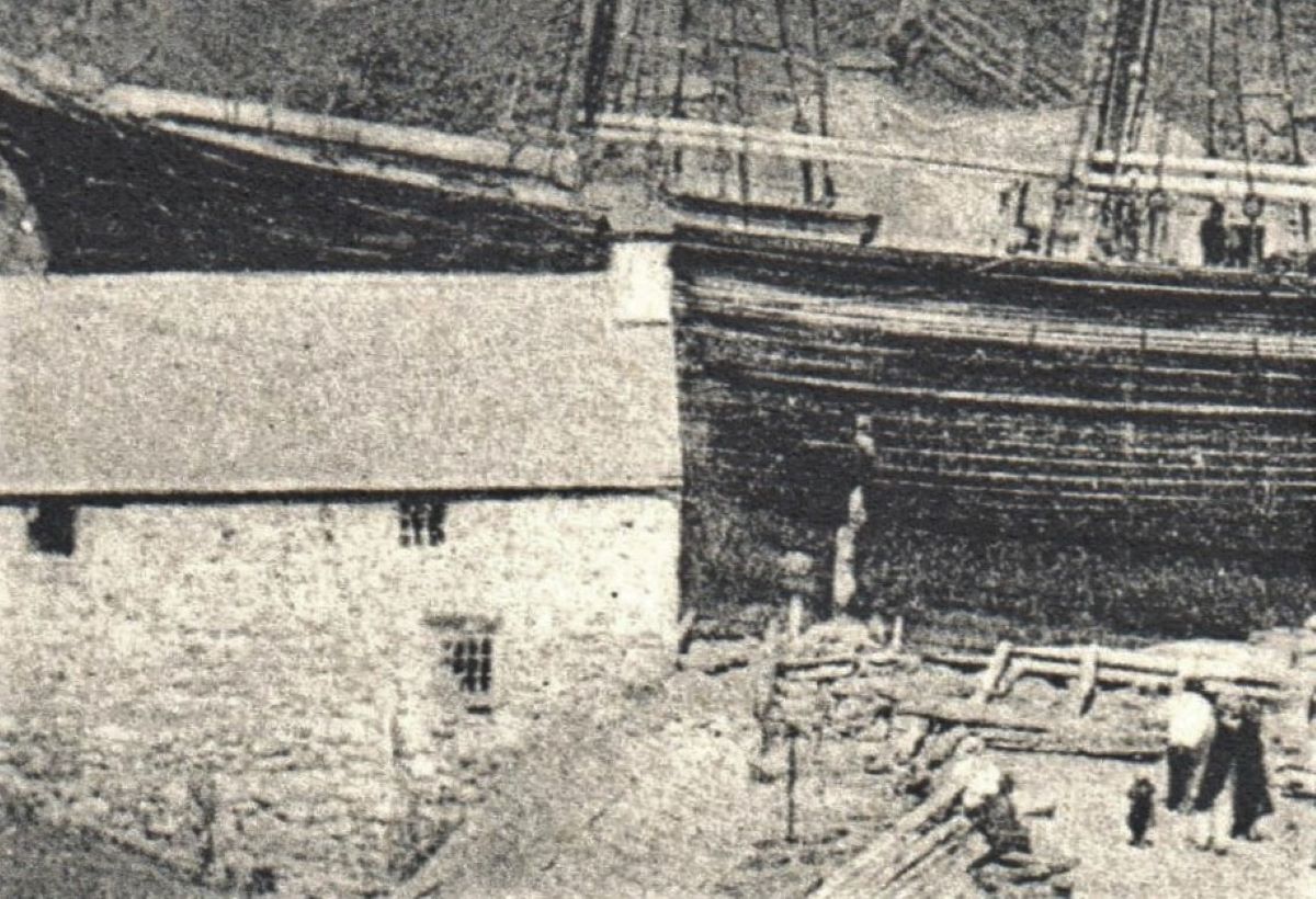
Illustration 2 Nefyn Beach Corner 1875
(Click photo to enlarge)
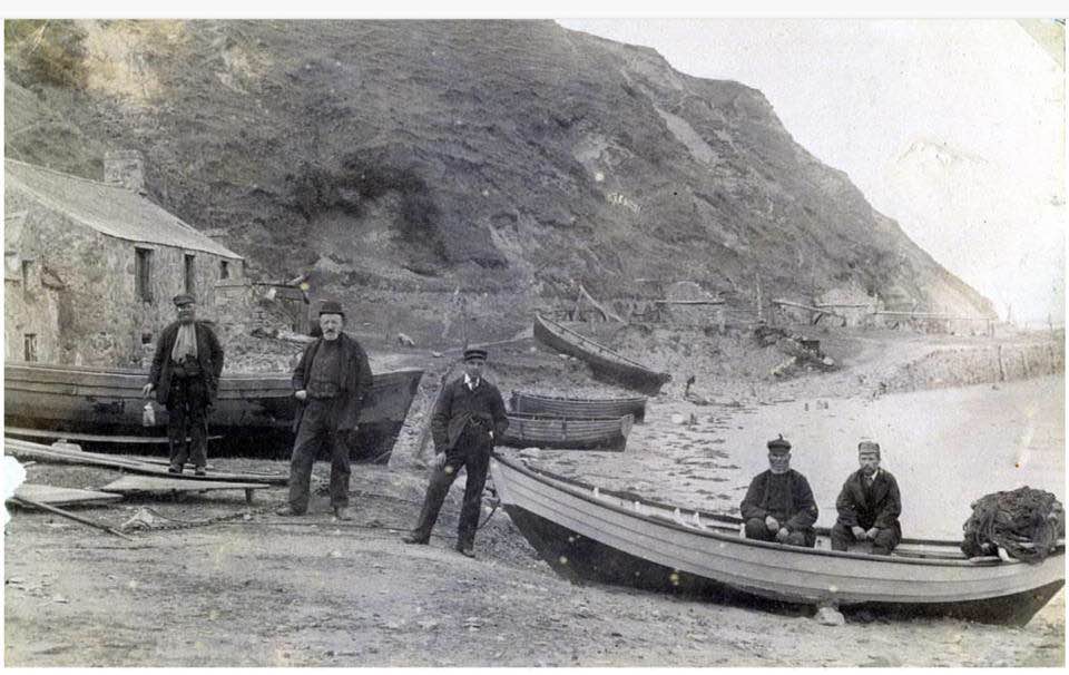
Illustration 3 Nefyn Beach Corner 1902
(Click photo to enlarge)
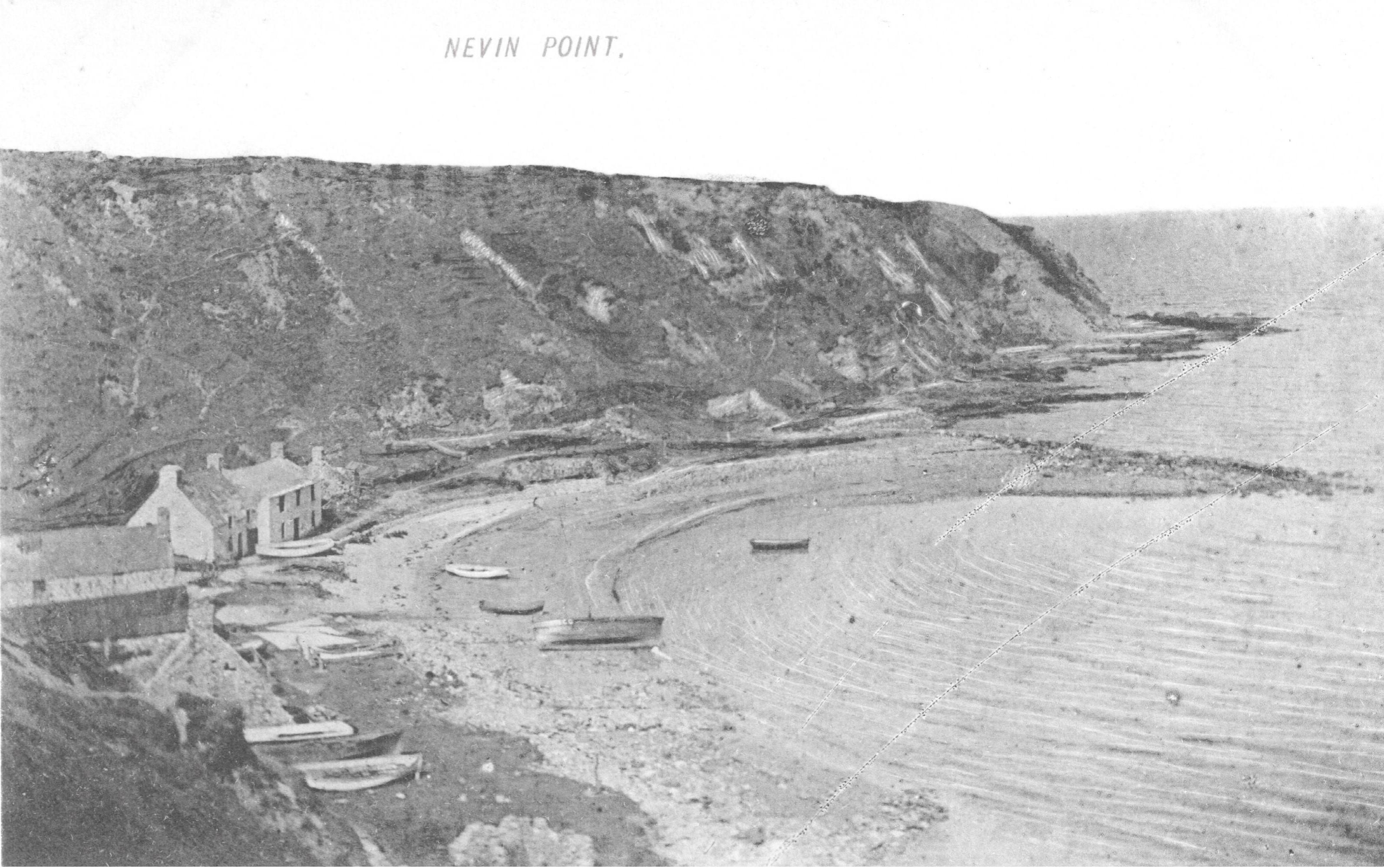
Illustration 4 Nefyn Beach Corner 1903
(Click photo to enlarge)
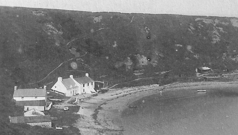
Illustration 5 Nefyn Beach Corner 1915
(Click photo to enlarge)
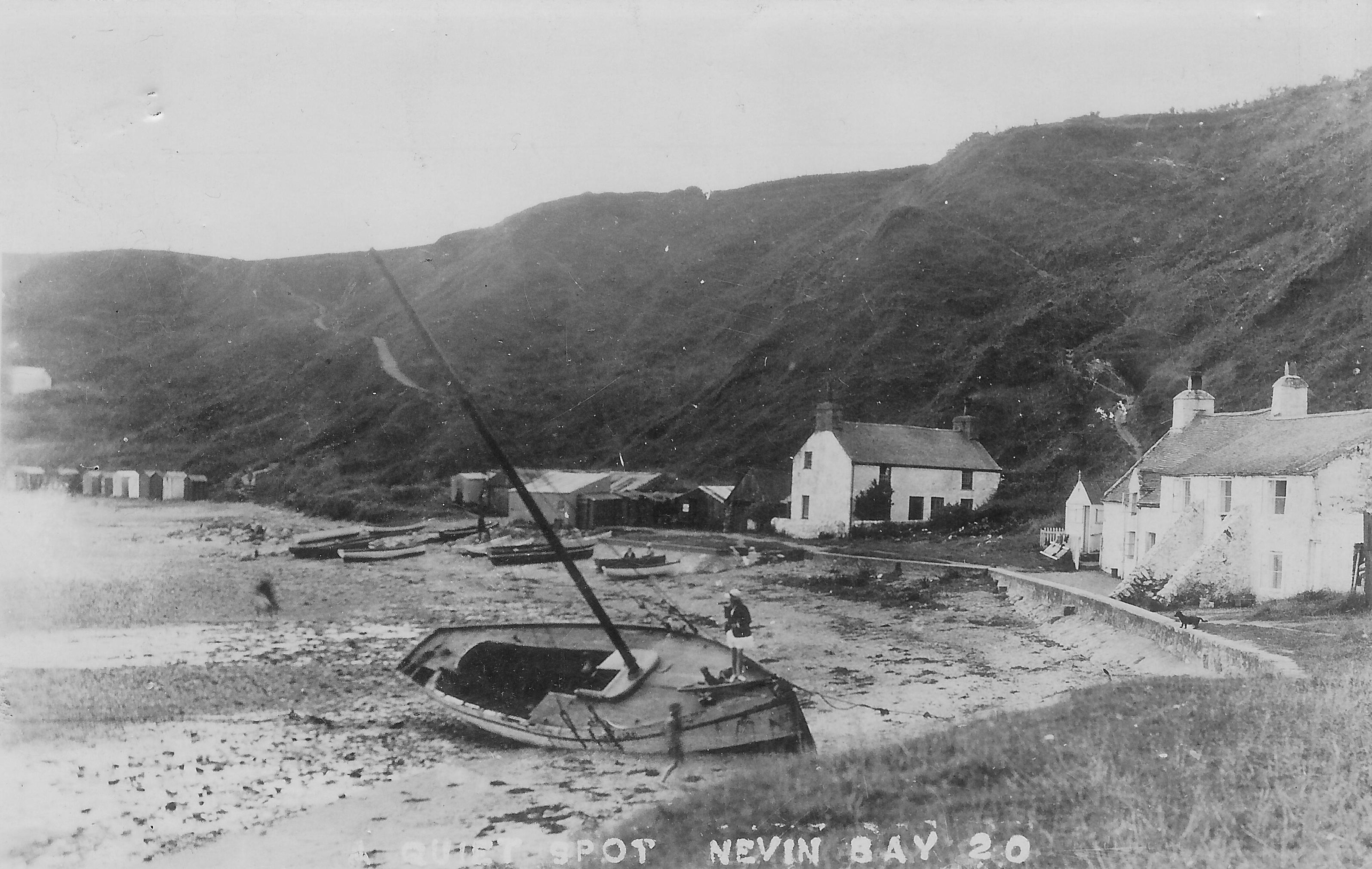
Illustration 6 Nefyn Beach Corner 1920
(Click photo to enlarge)
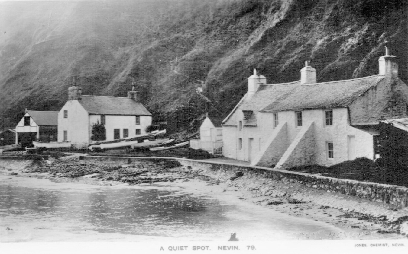
Illustration 7 Nefyn Beach Corner 1920
(Click photo to enlarge)
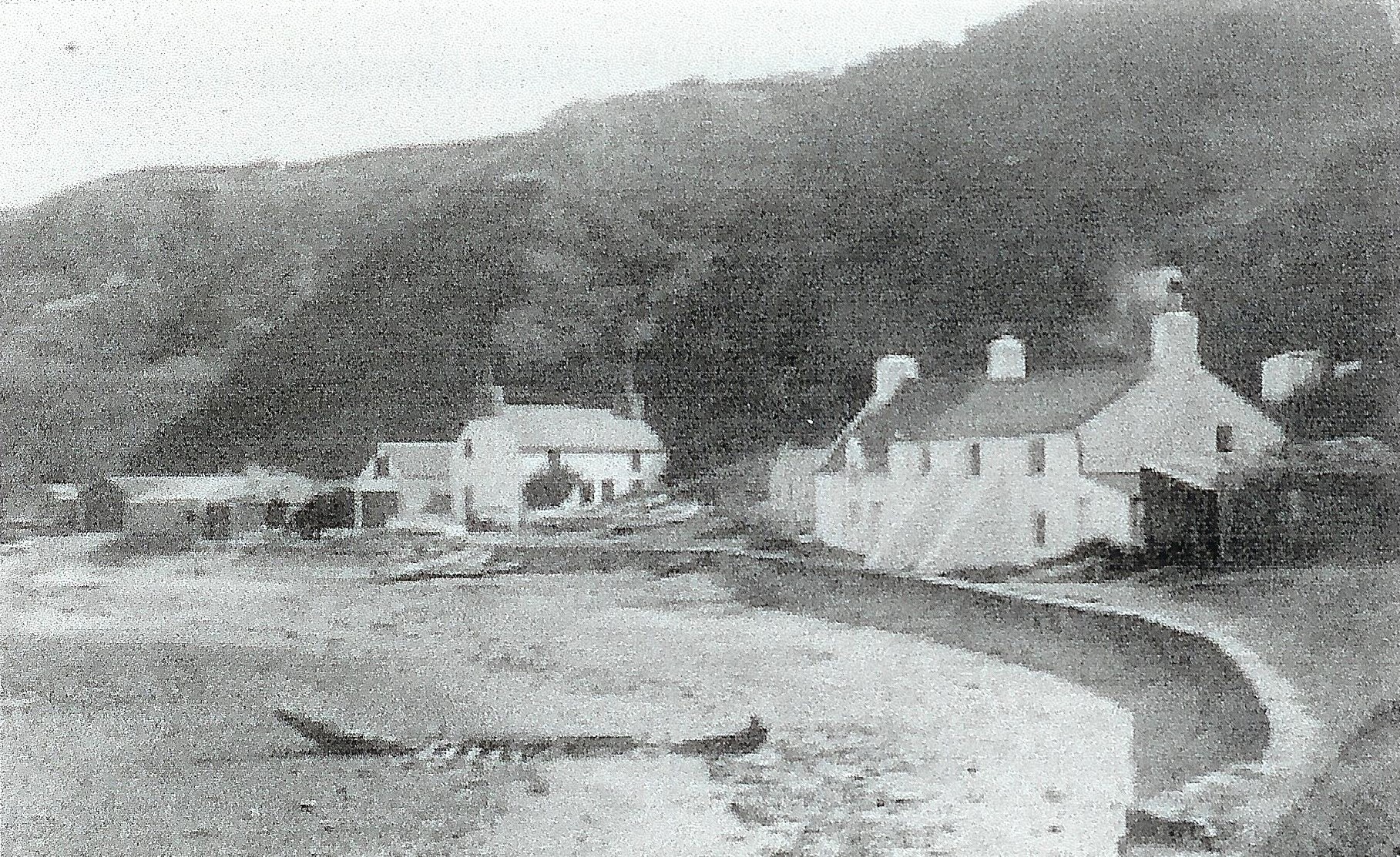
Illustration 8 Nefyn Beach Corner 1927
(Click photo to enlarge)
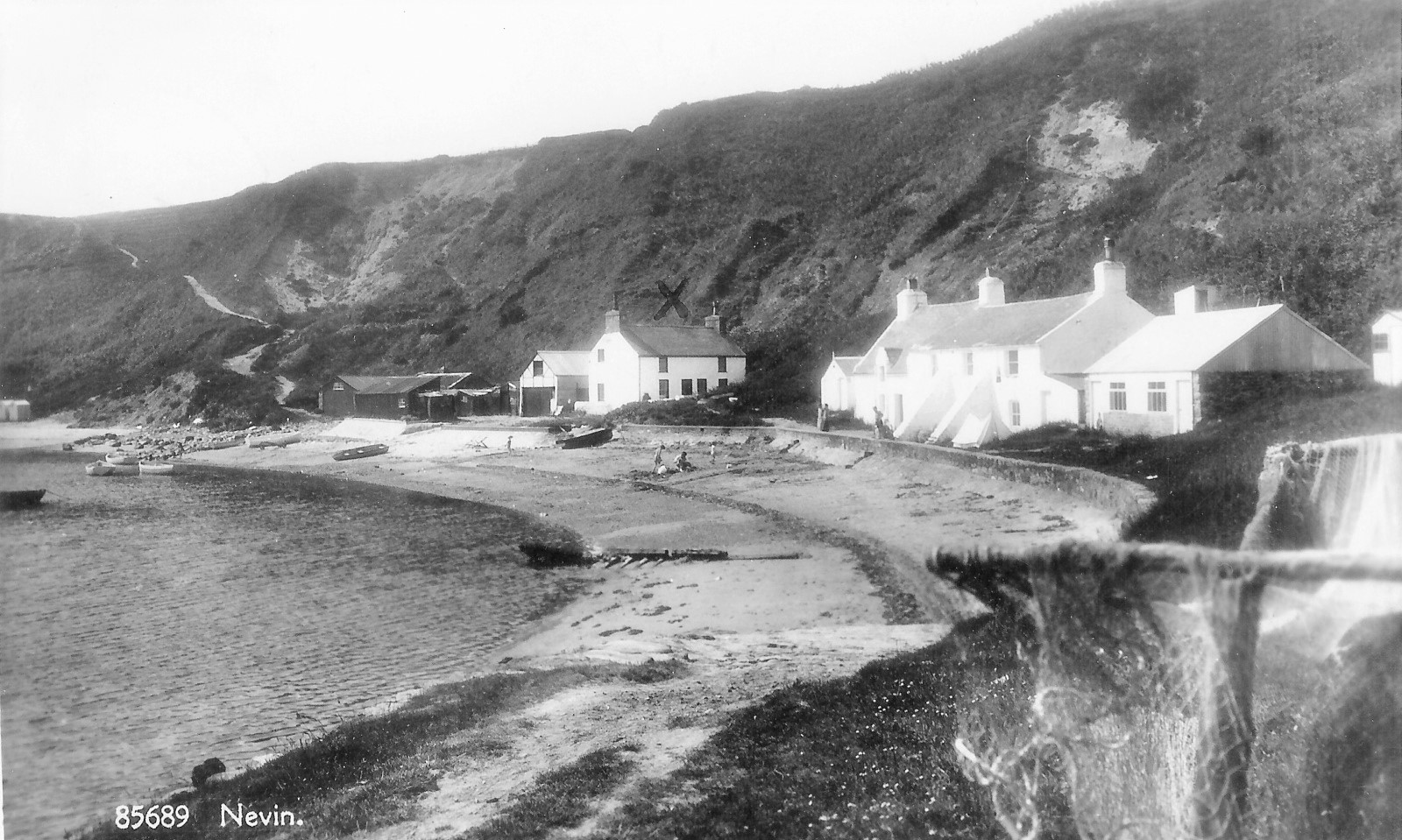
Illustration 9 Nefyn Beach Corner 1930
(Click photo to enlarge)
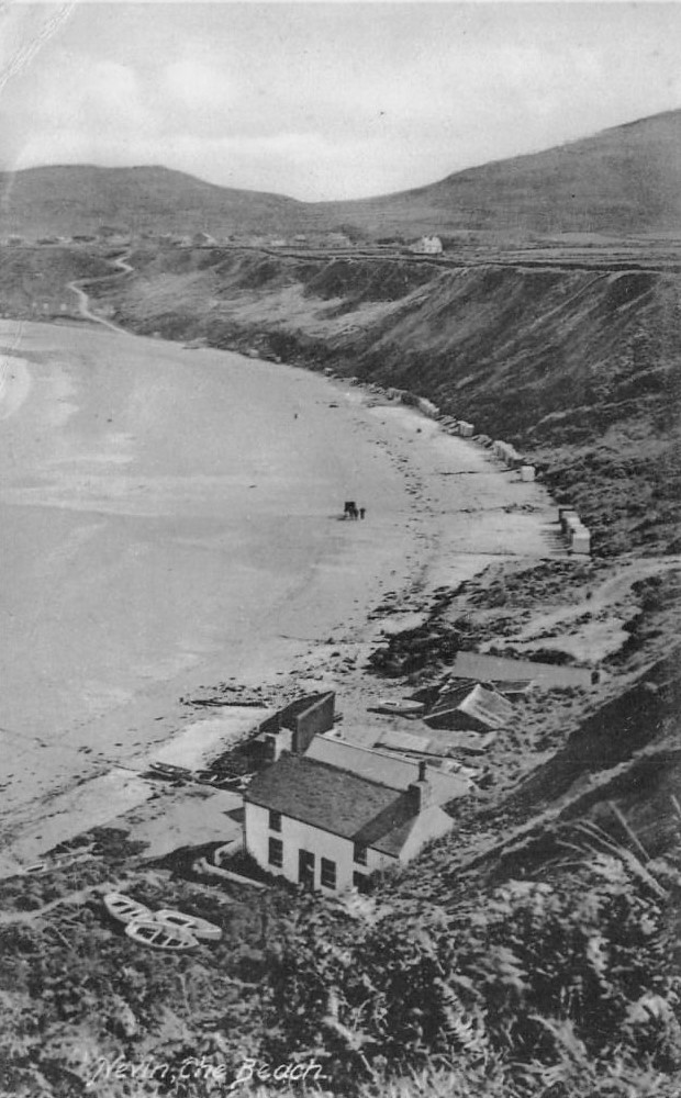
Illustration 10 Nefyn Beach Corner 1930
(Click photo to enlarge)
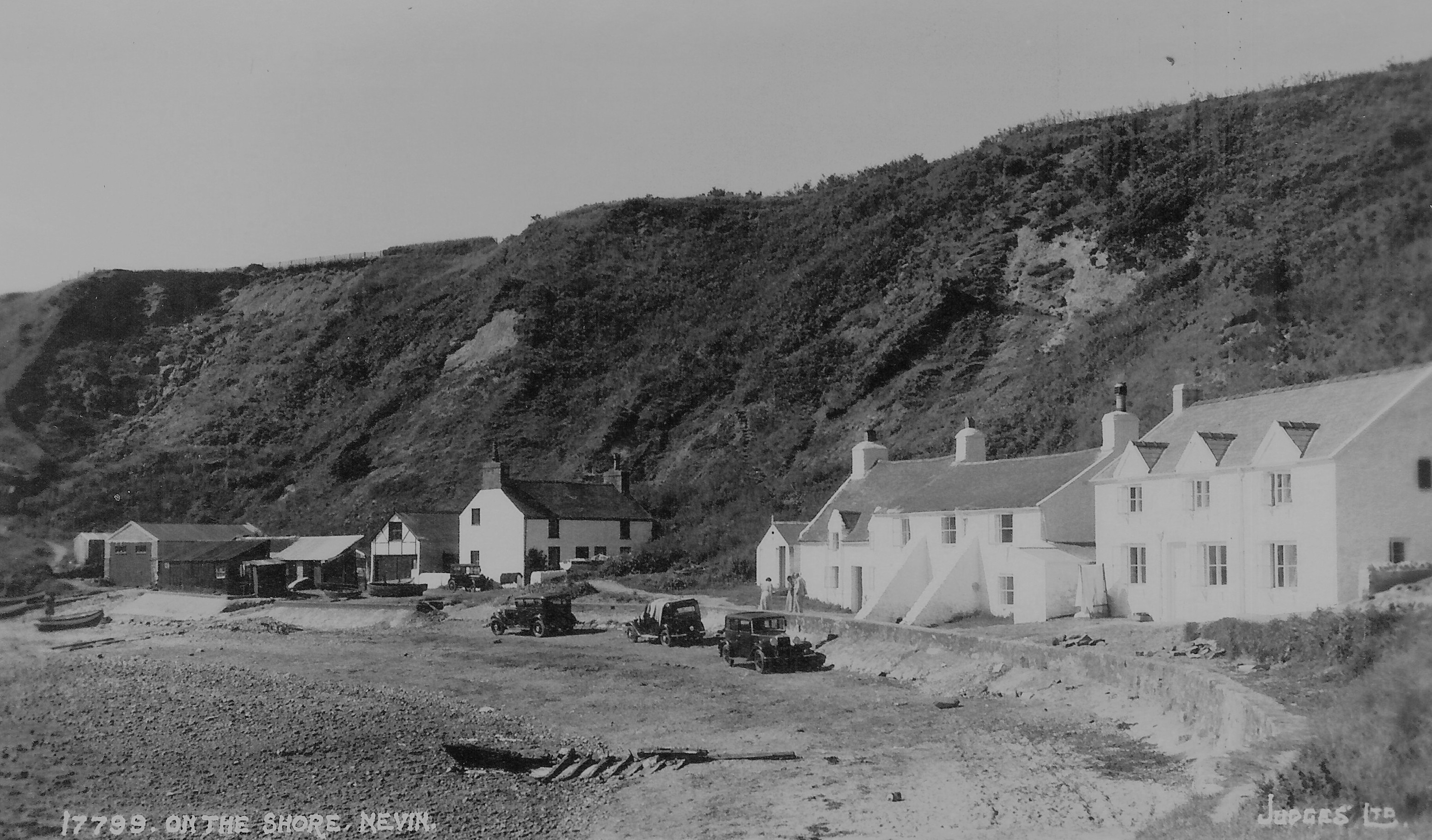
Illustration 11 Nefyn Beach Corner 1935
(Click photo to enlarge)
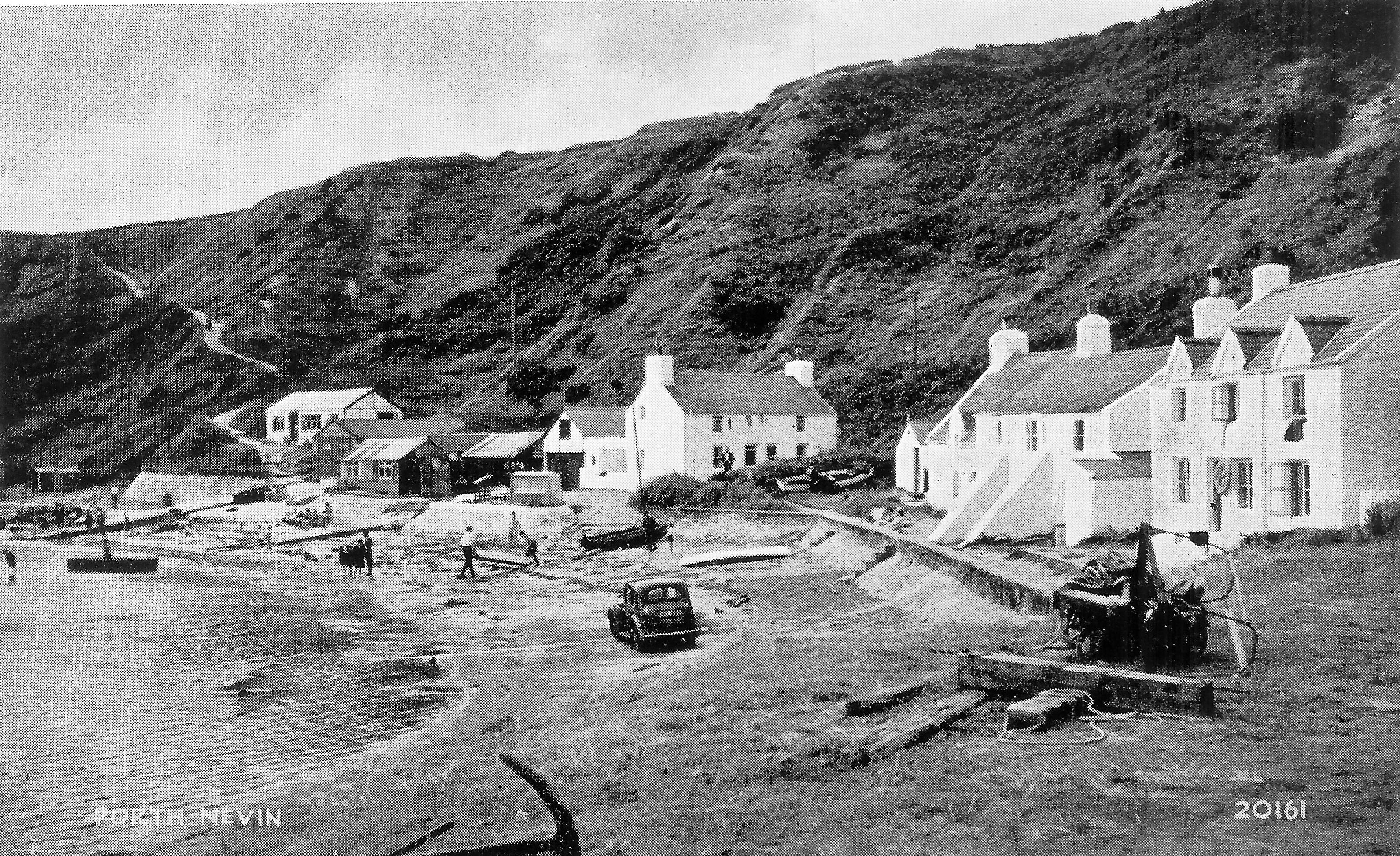
Illustration 12 Nefyn Beach Corner 1950
(Click photo to enlarge)
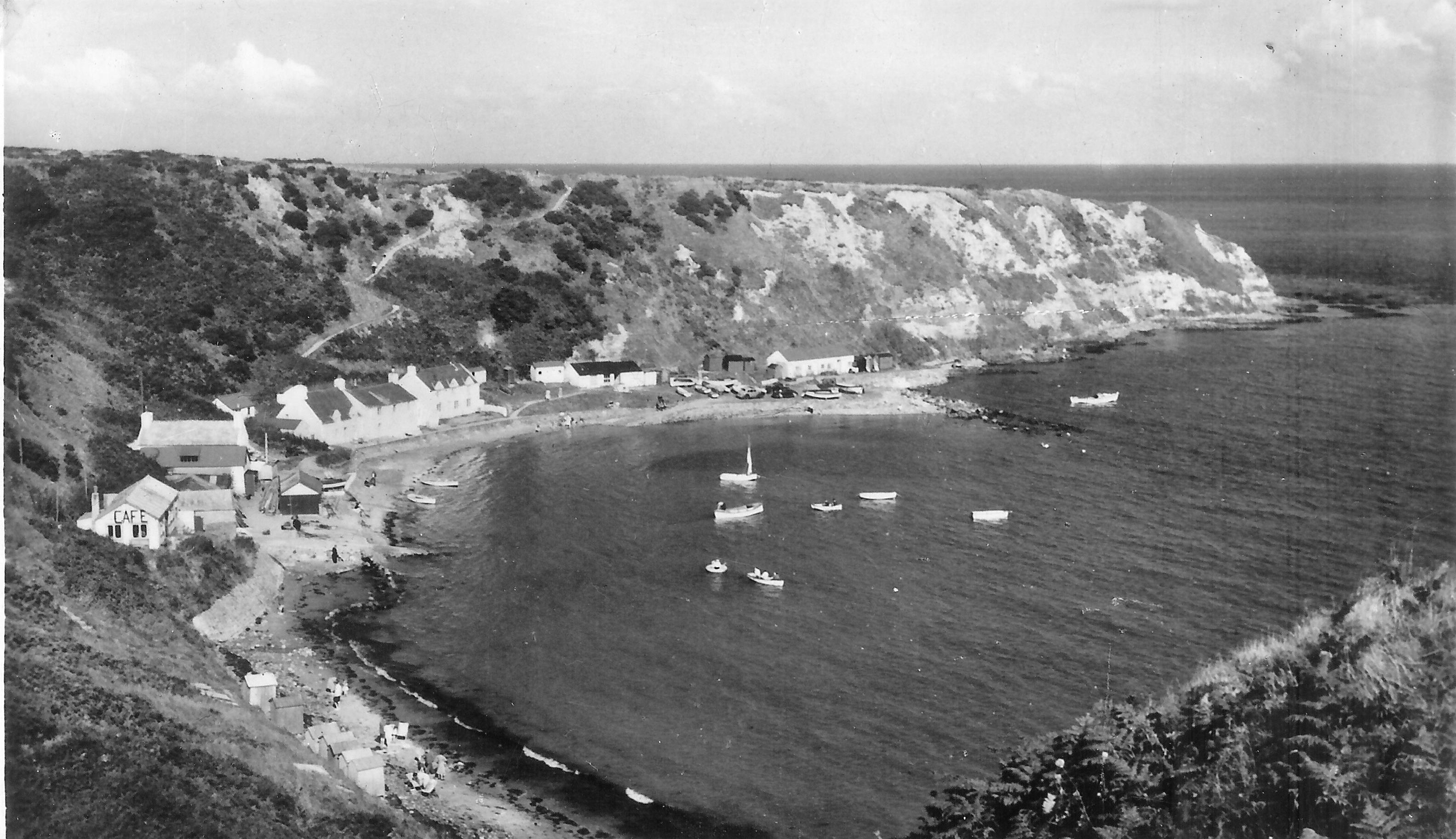
Illustration 13 Nefyn Beach Corner 1950
(Click photo to enlarge)
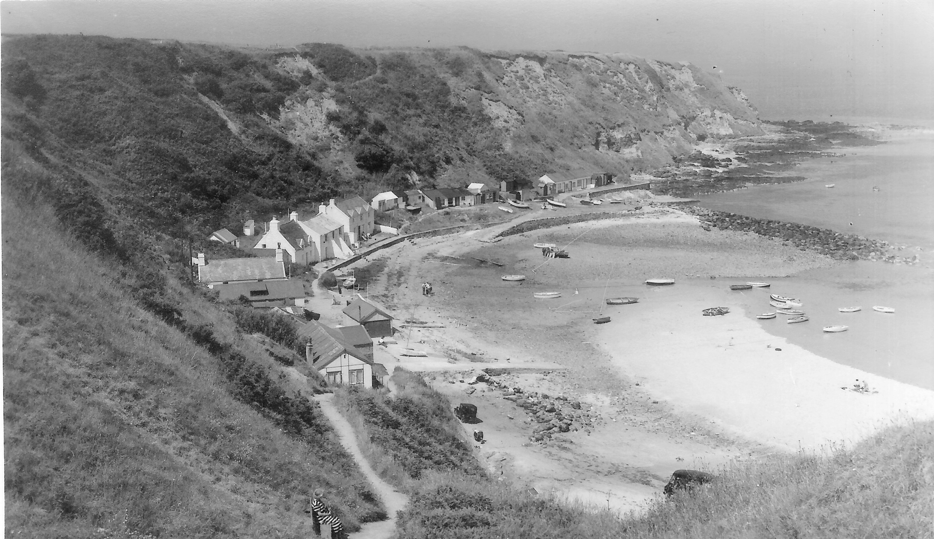
Illustration 14 Nefyn Beach Corner 1956
(Click photo to enlarge)
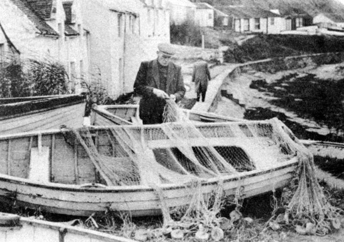
Illustration 15 Nefyn Beach Corner 1955
(Click photo to enlarge)
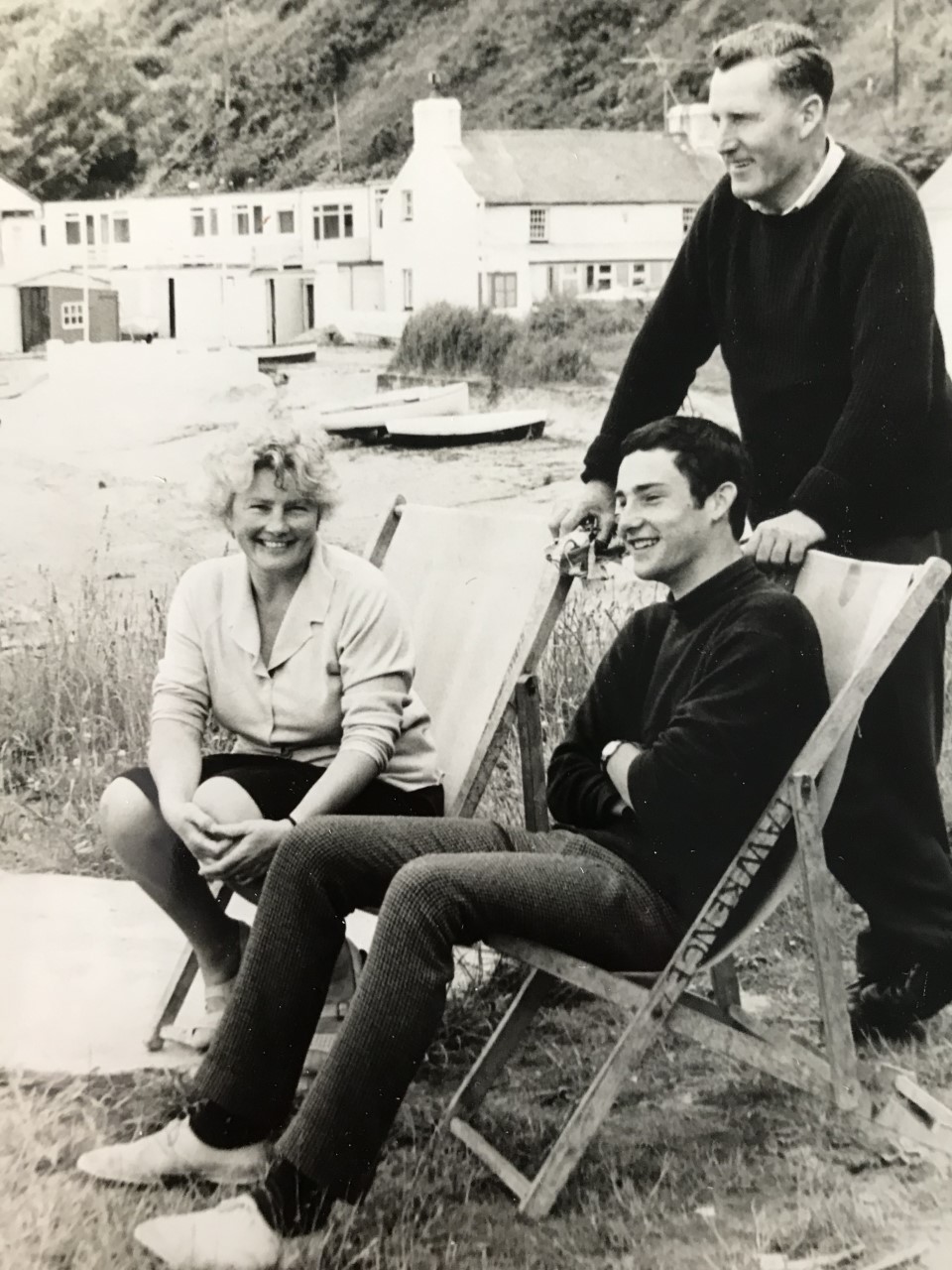
Illustration 16 Nefyn Beach Corner 1965
(Click photo to enlarge)
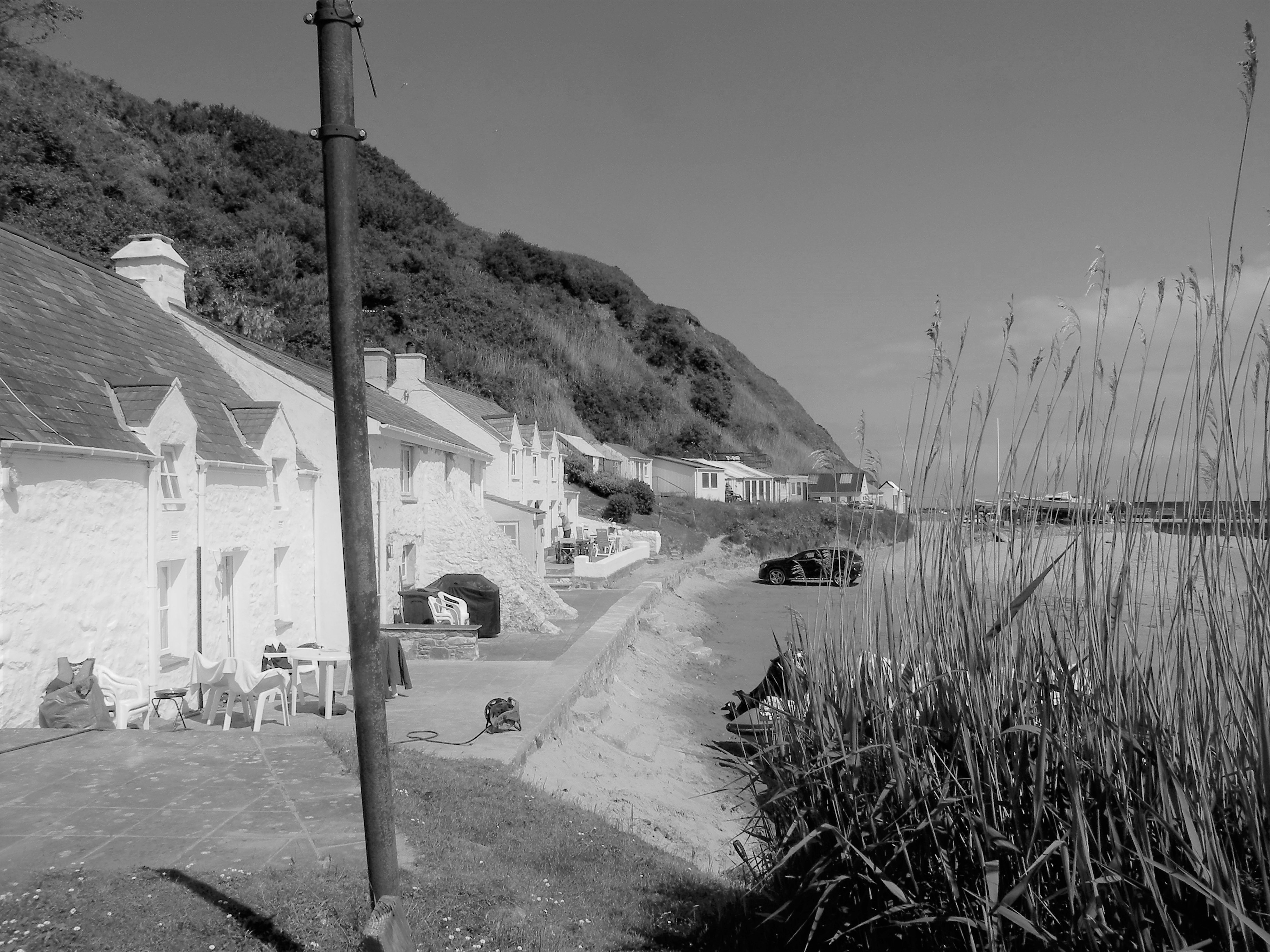
Illustration 17 Nefyn Beach Corner 2018
(Click photo to enlarge)
Dr. Brian Owen
Emmaus, PA, USA
Top of Page